

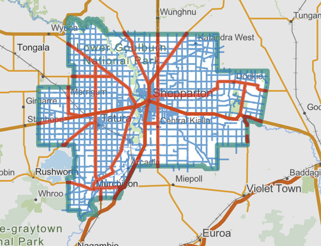
IN Victoria, road responsibility is divided between the State Government and local councils. The State Government’s Department of Transport and Planning (DTP), operating as Transport Victoria, manages major highways and arterial roads, which account for about 15 per cent of Victoria’s road network. Local councils manage the remaining 85 per cent, which includes residential streets and local rural roads.
In Greater Shepparton, DTP is responsible for maintaining major regional highways and primary arterial routes. This includes:
• Midland Highway
• Goulburn Valley Highway
• New Dookie Road
• Toolamba Road
• Murchison-Tatura Road
• Doyles Road
• Central Kialla Road
• Byrneside-Kyabram Road
• Rushworth-Tatura Road
• High Street
• Wyndham Street
Greater Shepparton City Council manages and maintains the local road and residential street network. This includes local urban streets such as Poplar Avenue, St Georges Road, Fryers Street, Nixon Street and Old Dookie Road. The Council is also responsible for managing adjacent community infrastructure, including public footpaths, local street lighting, school crossings and kerb or gutter systems.
You can explore the interactive local road asset map provided online at the Greater Shepparton City Council Road Maintenance Portal: https://greatershepparton.com.au/bpi/roads/road-maintenance
DTP also provides an interactive map illustrating the state-managed network, which includes major corridors such as the Hume Freeway, Murray Valley Highway, Monash Freeway, and the Northern Highway. You can explore this asset index live via the DTP Managed Road Network Map by visiting https://experience.arcgis.com/experience/068ac885fc3f47d4aecfea22c22c4e54.
Beyond the asphalt itself, DTP holds sole responsibility for managing and timing permanent traffic lights across Victoria, meaning local municipal councils do not look after electronic intersection signals.
For specialised corridors, private toll operators manage major tollways like CityLink or EastLink. Dedicated state forest roads and conservation tracks are maintained by environmental departments like Parks Victoria or the Department of Energy, Environment and Climate Action (DEECA).
If you need to report physical damage on a road in Victoria, or you have sustained vehicle damage due to unaddressed potholes or road hazards, identifying the governing authority is the first step to processing your request or claim.
Who to contact:
• Snap Send Solve: Download the smartphone app to take a photo of a local hazard. The app automatically determines your GPS location and forwards the report directly to the responsible local council or utility.
• Greater Shepparton City Council: Call (03) 5832 9700 for issues on local council streets or footpaths.
• Transport Victoria (DTP / VicRoads): Call the hazard hotline at 13 11 70 to report urgent issues like deep highway potholes or broken traffic signals.